
PrepSeven | IB Content Guide authored by Shankar Mutneja (Founder of Prepseven)
IB Geography
What Is IB Geography?
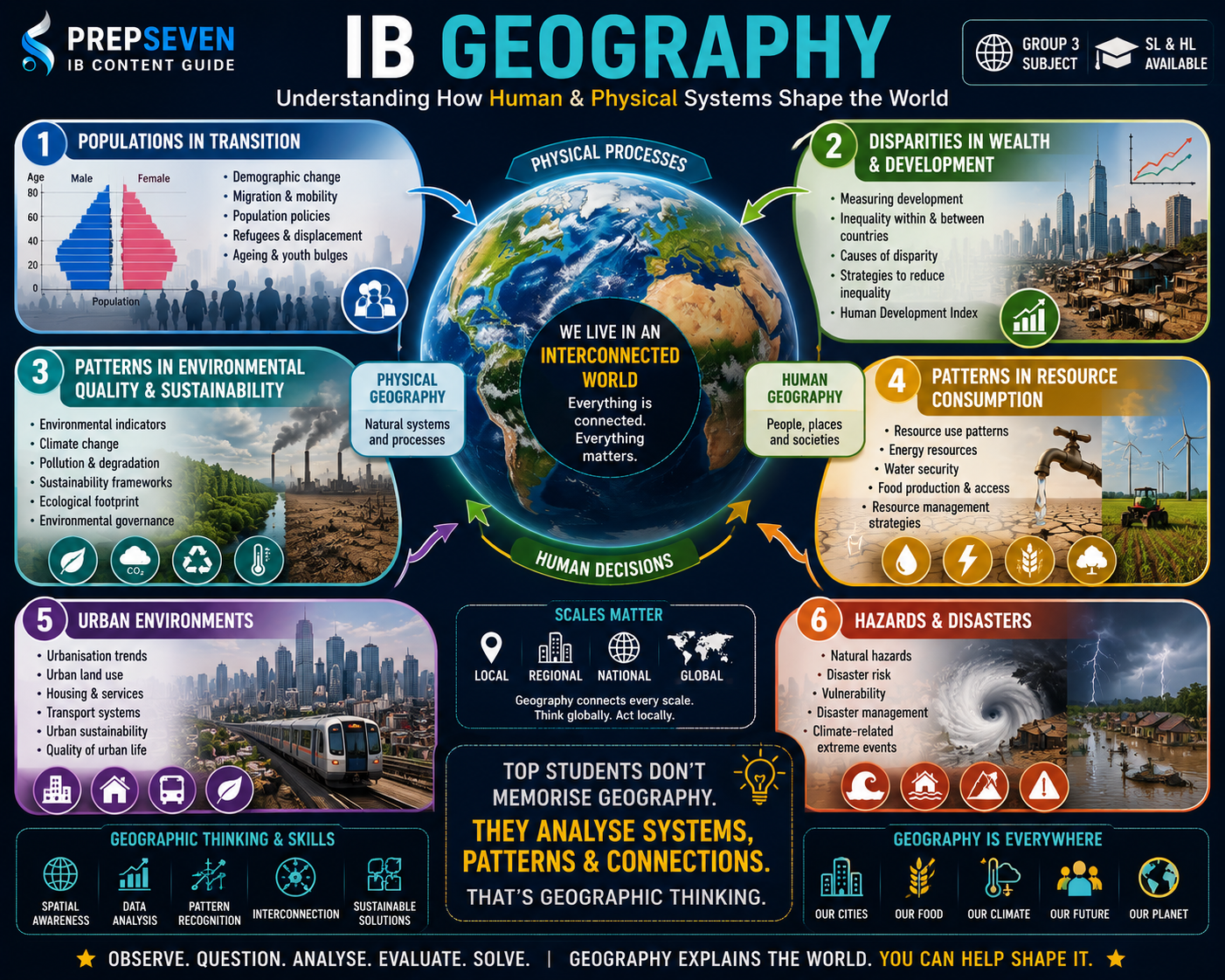
IB Geography is a course about understanding the world as an interconnected system of physical processes, human decisions, and environmental consequences. It sits in Group 3 of the Diploma Programme and is available at both Standard Level and Higher Level. Unlike many school geography courses that treat physical and human geography as separate disciplines, IB Geography weaves them together throughout, asking students to understand how natural processes and human societies shape and are shaped by each other.
The course is built around a core syllabus studied by all students, an optional themes section where schools choose two from a list of thematic areas, and at HL an additional extension component. The Internal Assessment requires students to conduct their own geographic fieldwork, which is one of the most distinctive features of the course and one of its most rewarding when done well.
What makes IB Geography genuinely challenging, and genuinely interesting, is that it refuses to let students sit comfortably with simple explanations. Climate change is not just a science problem. It is a political, economic, and ethical problem simultaneously. Urbanisation is not just about population growth. It is about governance, inequality, cultural change, and environmental sustainability. Students who engage with this complexity, who are willing to hold multiple framings of a problem at once, consistently perform better than those who look for single-cause explanations.
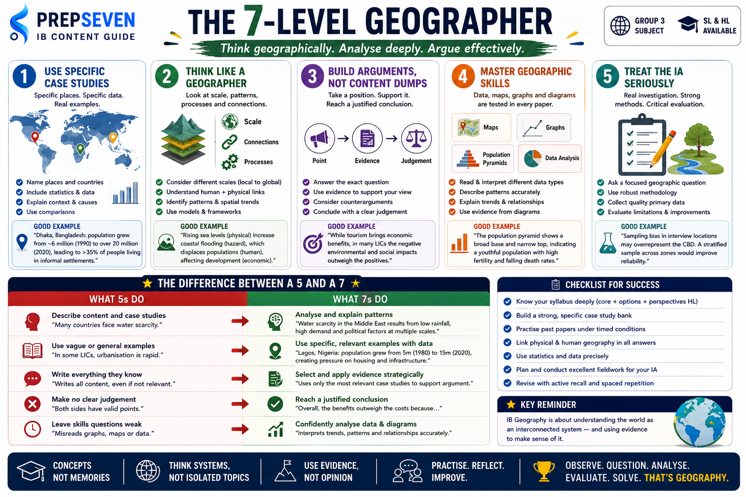
IB Geography is not primarily a memorisation course. Students who spend most of their preparation time memorising case studies and definitions, without developing the ability to apply geographic concepts to unfamiliar situations and evaluate them from multiple perspectives, consistently plateau around the 5 to 6 range. The top band requires analysis, evaluation, and the ability to construct a justified argument using geographic evidence.
SL vs HL: What the Difference Involves
The difference between Geography SL and HL is significant and worth understanding clearly before committing to a level. HL students cover additional core content, study the Geographic Perspectives extension, and sit a third exam paper that is not assessed at SL.
Paper 3 at HL is a significant additional component. It is a synoptic paper that requires students to integrate knowledge across the entire HL syllabus, including the Geographic Perspectives extension, and apply it to unseen stimulus material. The Geographic Perspectives extension covers three areas: global interactions, power and places, and global commons. These are conceptually demanding topics that require genuine engagement throughout Year 2, not last-minute revision.
If you are planning to study geography, environmental science, urban planning, development studies, or any spatial or environmental discipline at university, Geography HL is a meaningful preparation. The fieldwork skills, the ability to work with geographic data, and the systems thinking the course develops are all directly relevant to undergraduate study in these fields. Selective geography programmes at UK, European, and North American universities increasingly view HL Geography as evidence of subject-specific preparation.
What the Syllabus Covers
The Core: Studied by All Students
The core syllabus covers four major topics that form the foundation of the course. Every student, SL and HL, studies all four.
The Optional Themes: Chosen by Your School
Schools choose two from seven optional themes. Both are examined in Paper 2. The seven options are:
Your school selects which two optional themes to teach. You need to know both thoroughly for Paper 2. Confirm which two options your school offers as early as possible in Year 1 and engage with both from the start. Students who discover midway through Year 2 that they have been revising for an optional theme their school does not teach face a serious problem with no easy solution.
Assessment Breakdown: How You Are Graded
Paper 1: The Core
Paper 1 is one hour thirty minutes at SL and two hours fifteen minutes at HL. It tests the four core topics through structured questions and extended response questions. Section A contains short structured questions, one on each core topic, and you answer all four. Section B contains extended response questions and you answer one.
The structured questions in Section A test breadth of knowledge across all four core topics. They typically build through multiple parts, starting with definitions or descriptions worth small marks and progressing to analysis or evaluation worth more. Reading each question carefully matters here: a question asking you to describe a pattern in data is different from a question asking you to explain why that pattern exists, and different again from a question asking you to evaluate a management strategy in response to that pattern.
The Section B extended response is where the highest individual marks in Paper 1 are available and where performance varies most. These questions ask you to examine, discuss, or evaluate a geographic concept or issue drawing on your knowledge of the core topics. A strong response does three things: it demonstrates accurate geographic knowledge, it applies that knowledge analytically to the specific question rather than reproducing prepared content in a different order, and it reaches a justified conclusion or judgement. Students who write everything they know about a core topic in response to an extended response question, without shaping it into an answer to the specific question asked, consistently score below the top band.
Case studies are essential in Paper 1 and you need them to be specific. A response that mentions that some countries have high population growth without naming countries, dates, or specific circumstances earns much less credit than one that discusses Uganda’s total fertility rate in the context of the demographic transition model, the specific policies the Ugandan government has attempted, and the barriers to demographic transition in sub-Saharan African contexts. Specificity is what the mark scheme rewards. Build a case study bank that is specific enough to use in this way.
Paper 2: The Optional Themes
Paper 2 is one hour at SL and one hour twenty minutes at HL. It contains essay questions on the two optional themes your school has taught, and you write one essay per theme. Each essay is worth ten marks and you choose which question to answer within each theme.
Paper 2 essays require sustained analytical argument supported by specific geographic evidence. The questions tend to be evaluative or discursive: to what extent, examine the view that, discuss the consequences of. A strong Paper 2 essay has a clear position stated early, develops it through specific geographic examples, considers counterarguments or alternative perspectives, and concludes with a justified position. A weak one describes geographic processes and case studies without constructing an argument around them.
The optional theme essays reward students who know their themes deeply enough to deploy evidence selectively in support of an argument rather than comprehensively as a content display. If you know five case studies for your Hazards and Disasters option, the question determines which two or three are most relevant to the specific argument you are making. Choosing your evidence strategically, rather than mentioning everything you know, is what distinguishes the top band.
Paper 3: HL Geographic Perspectives
Paper 3 is one hour at HL and covers the Geographic Perspectives extension, which explores global interactions, power and places, and global commons. It presents unseen stimulus material and asks you to respond to extended questions that require you to integrate knowledge from across the HL syllabus.
Paper 3 is the most synoptic component of the IB Geography assessment. It requires you to bring together concepts and evidence from the core, from your optional themes, and from the Geographic Perspectives extension, and apply them to a new scenario or argument. Students who have only revised their topics in isolation, without practising cross-topic connections, find Paper 3 significantly harder than those who have developed a mental map of how the syllabus fits together.
The Global Commons section of the Geographic Perspectives extension deserves particular attention. It covers Antarctica, the high seas, the atmosphere, and outer space as areas beyond national jurisdiction. The questions this raises about governance, resource management, climate responsibility, and international cooperation connect directly to all four core topics and to most of the optional themes. Students who understand the Global Commons well often find that it enriches their answers across the entire exam, not just Paper 3.
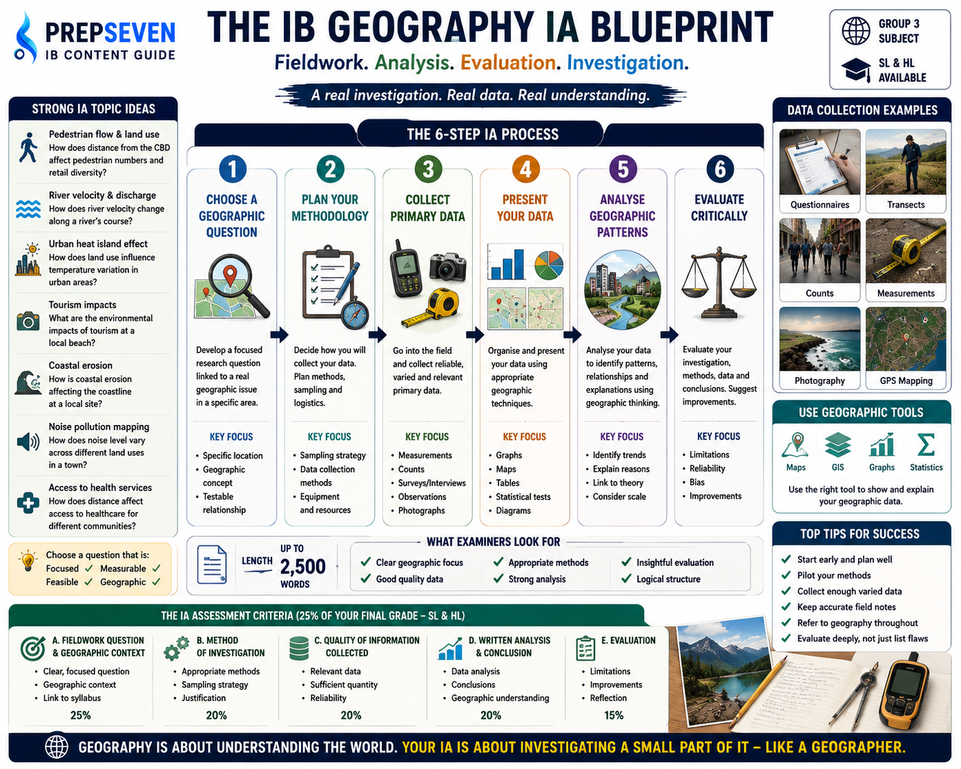
Internal Assessment: The Fieldwork Report
The Internal Assessment is a geographic fieldwork report of up to 2,500 words. You design and conduct your own fieldwork investigation, collect data in the field, analyse it using appropriate geographic methods, and write it up in a structured report. It carries 25% of the final grade at both SL and HL.
The IA is assessed on five criteria: Fieldwork Question and Geographic Context, Method of Investigation, Quality of Information Collected, Written Analysis and Conclusion, and Evaluation. The Method and Evaluation criteria are consistently where students either demonstrate genuine geographic thinking or reveal that they went through the motions of data collection without understanding what they were doing or why.
The Evaluation criterion is where the most marks are consistently left on the table. A strong evaluation does not just say that the investigation had limitations. It identifies specific methodological weaknesses, explains how those weaknesses affected the data quality and the conclusions that could be drawn, and suggests concrete improvements that would address them. An evaluation that says the sample size was small and that interviewing more people would improve the study earns partial credit. An evaluation that explains why the spatial distribution of interview locations introduced systematic bias, what effect that bias likely had on the findings, and how a stratified sampling approach across different socioeconomic zones would have produced more reliable data is working at the level the top criterion band rewards.
The single most important strategic decision in the IA is choosing a fieldwork question that is genuinely geographic, that you can investigate with data you can realistically collect, and that is focused enough to analyse in depth within 2,500 words. A question like What is the impact of urbanisation on a local area is too broad. A question like To what extent does distance from the Central Business District affect pedestrian flow and retail diversity in [named town] is appropriately focused, testable with primary data you can collect, and rich enough for genuine geographic analysis. Discuss your research question with your teacher before collecting any data.
Case Studies: Why Specificity Is Everything
Case studies are not optional extras in IB Geography. They are the primary form of geographic evidence in both exam papers and the only way to demonstrate that your geographic knowledge is grounded in the real world rather than abstract theory. But the way you use case studies matters as much as which ones you know.
There is a consistent pattern in IB Geography examiner reports: students who name specific places with specific data earn significantly more marks than students who discuss the same concepts in general terms. The difference between writing that many developing countries experience rapid urbanisation and writing that Dhaka, Bangladesh, experienced population growth from approximately 6 million in 1990 to over 20 million by 2020, driven by rural-urban migration related to agricultural mechanisation and flooding in the delta region, with the result that over 35% of its population now lives in informal settlements with inadequate sanitation, is the difference between a partial answer and a fully developed one.
You do not need an enormous number of case studies. You need a manageable number known in genuine depth. For each core topic, two to three well-understood case studies that you can deploy flexibly across different question types is more valuable than ten superficially known ones. For each optional theme, a similar depth across the key sub-topics is what the mark scheme rewards.
A practical case study strategy: for each case study you develop, ensure you know at minimum the specific location and its geographic context, the specific processes or events you are using it to illustrate, at least two or three specific data points such as statistics, dates, or named outcomes, the scale at which the issue operates from local to global, and at least one contrasting case that allows comparison. This depth of knowledge is what allows you to use a case study analytically rather than just descriptively.
What Actually Gets Students to a 7
They apply concepts to unfamiliar contexts, not just familiar ones
IB Geography exams regularly present scenarios, data, or case studies that students have not seen before and ask them to apply geographic concepts to these new situations. Students who have genuinely understood geographic concepts, who know why a demographic transition occurs and what conditions accelerate or slow it, can apply that understanding to a country they have never specifically studied. Students who have only memorised examples from their notes cannot. The preparation that builds this kind of transferable understanding is not more case study memorisation. It is regular practice thinking through geographic questions: what processes are at work here? What is the scale of this issue? What are the human and physical dimensions? What would different geographic frameworks say about this?
They use data and statistics specifically rather than vaguely
Geography exams reward quantitative precision. A response that says population growth rates are high in sub-Saharan Africa is less convincing than one that says Niger had a total fertility rate of approximately 7 children per woman as of recent data, one of the highest in the world, reflecting low female literacy rates, limited contraceptive access, and the economic value of children in agricultural communities. The statistics do not need to be exact. They need to be in the right order of magnitude and used to support an argument rather than simply cited. Build the habit of learning at least one or two specific figures for every case study you develop.
They construct arguments, not just content displays
The extended response questions in Paper 1 Section B and the essays in Paper 2 are not asking you to tell the examiner everything you know about a topic. They are asking you to construct an argument in response to a specific question. This requires three things: a position that the question has given you scope to take, evidence deployed selectively in support of that position, and a conclusion that synthesises the argument rather than summarising the content. Students who write excellent content without argument structure consistently score in the mid-range. Students who construct clear arguments with specific geographic evidence reach the top band.
They engage with the geographic skills assessed in Paper 1
Paper 1 frequently presents geographic data in the form of graphs, maps, tables, photographs, or population pyramids and asks students to interpret, describe, or analyse them. These questions test geographic skills as much as geographic knowledge, and they are skills that need practice throughout the course rather than revision cramming before the exam. Practise reading and interpreting different types of geographic data regularly: describe what a distribution map shows, explain what a population pyramid reveals about a country’s demographic profile, analyse what a graph of HDI trends over time suggests about development patterns. These are discrete skills with a learning curve.
They take the IA fieldwork seriously as a genuine investigation
Students who approach the IA as a box-ticking exercise, collecting the minimum data required and writing a formulaic report, consistently produce work that scores in the lower criterion bands regardless of how capable they are in the exam papers. Students who approach the IA as a genuine geographic investigation, asking a real question they are curious about, collecting robust and varied data, analysing it using appropriate geographic methods, and reflecting honestly on the limitations of their methodology, produce work that scores at the top. The IA rewards authentic geographic thinking more directly than any other component of the course.
Common Mistakes That Cost Marks
A Realistic Year-by-Year Approach
Year 1 (Grade 11): Build Knowledge and Geographic Thinking
- Engage with each core topic as it is taught by building structured case study notes immediately. For every new country or region discussed in class, note the specific data, the geographic context, and the processes at work, not just the general theme.
- Confirm which two optional themes your school teaches within the first week of the course and begin engaging with both from the start of Year 1. Do not wait until Year 2 to start learning your optional themes.
- Practise interpreting geographic data regularly. Every time a graph, map, or data table appears in class, practise writing two or three sentences describing and then explaining what it shows. This builds the skill before exam pressure arrives.
- Begin planning your IA fieldwork question by the end of Term 2 in Year 1. Discuss feasibility with your teacher and identify your data collection methods before the formal IA period begins in Year 2.
- For HL students: engage with the Geographic Perspectives extension content as it is introduced. Do not defer it to Year 2. The synoptic thinking Paper 3 requires needs time to develop.
Year 2 (Grade 12): Deepen Analysis and Prepare to Perform
- Complete at least four full past paper sets under timed conditions before your mock exams, covering Papers 1 and 2 and for HL students Paper 3. Mark your responses using the IB markscheme and identify the specific types of questions where you consistently lose marks.
- Practise writing timed extended response answers to Paper 1 Section B questions and Paper 2 essay questions. Focus each revision session on constructing an argument rather than reproducing content, and practise selecting which case studies are most relevant to each specific question rather than using the same ones for every answer.
- Complete your IA data collection early in Year 2 and submit a first draft of the full report for teacher feedback before the end of Term 1. The Evaluation criterion in particular benefits from the feedback cycle.
- In the final revision period, build cross-topic connections between your core topics, your optional themes, and for HL the Geographic Perspectives extension. Draw a conceptual map that shows how the major themes of the course connect, and practise questions that require you to draw on more than one topic area simultaneously.
How PrepSeven Helps You Score Higher in IB Geography
IB Geography rewards two things that are difficult to develop alone: the ability to construct geographic arguments using specific evidence under time pressure, and the fieldwork thinking that produces an IA with genuine analytical depth. Our Geography tutors are certified IB examiners and experienced teachers who have marked student work across all three papers and the IA, and who know exactly where marks are made and lost in each component.
- Paper 1 sessions where you write a timed extended response and your tutor marks it against the IB criteria, showing you specifically where your argument loses focus, where case study evidence is too vague, and where your conclusion needs to be more directly justified.
- Paper 2 essay sessions where your tutor works through optional theme questions with you, building your ability to construct a geographic argument and deploy case study evidence selectively rather than comprehensively.
- Paper 3 synoptic sessions for HL students that build the cross-topic connections the Geographic Perspectives questions require, using past paper stimulus material to practise applying the HL extension content alongside core and optional theme knowledge.
- IA mentorship from fieldwork question design through to final draft submission, with particular attention to the Method of Investigation and Evaluation criteria where the most marks are consistently left on the table.
Book your free demo lesson at prepseven.com and bring a recent Geography essay or a core topic you are struggling to apply analytically. Your tutor will show you exactly what a top-band response to the same question looks like and how to close the gap.